Tullychurry Forest to Bog restoration
Introduction
A section of afforested blanket bog was offered by Forest Service (DAERA) for restoration as part of the Source to Tap Interreg VA project. The 30 ha area, known as Tullychurry Forest, is located in County Fermanagh close to the Donegal border. Lough Awaddy lies to the north of the restoration site, which sits between two lobes of Pettigoe Plateau, a designated Ramsar site, Area of Special Scientific Interest (ASSI), Special Protection Area (SPA) and Special Area of Conservation (SAC). The SAC is 1,270 Ha, making it one of the
largest expanses of blanket bog left in Northern Ireland. Of special scientific interest are Marsh Fritillary butterflies, Greenland white-fronted geese (in the winter) and hen harriers, which regularly hunt over the bog. The restoration work at Tullychurry will join up two lobes of open bog and re-establish the habitat for breeding birds and invertebrates. The removal of the Lodge Pole Pine plantation, should aid the endangered Golden Plover, whose predators will no longer have cover.
Description
The site was planted in the 1960’s using a ridge and furrow pattern typical for the time. This had to be dealt with to allow the water table to rise evenly. The site was harvested between December 2019 and the end of March 2020 by Forest Service (DAERA) contractors. Where trees were severely stunted, windblown or damaged by wildfire, the decision was taken to leave them in situ due to the cost of removal and the short expected timeframe for decomposition of 10-15 years. Project staff visited the site in June 2020 and noted large amounts of brash post harvest (one mat every 15m).
Project Aims
The Tullychurry restoration work will provide carbon sequestration and biodiversity benefits at a formerly harvested forestry site. The insight and data gained from this pilot project will inform future work in drinking water catchments. Indeed, the cell bunding technique has already been used at another restoration site, the nearby Lough Bradan reservoir.
Restoration Delivered
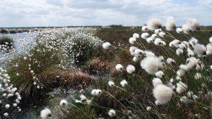
Work to restore just over 20 hectares of land that was previously planted with lodge pole pine has been completed within the INTERREG VA Source to Tap project. Already we are observing that the water levels are raised and that sphagnum mosses are starting to re-colonise. Over time as this continues the peatland will restore.
Site Activity
The site was split into 3 ‘treatment’ areas for the restoration work:
1. An intensive restoration area, where the new technique cell bunding was trialled.
2. A general drain blocking area, in which peat dams were used.
3. A control area, which aimed to mirror Forest Service best practice.
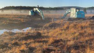
Work started at the end of October 2021 using 2 diggers with 0.5m wide tracks and a 1.2m bucket. The work at the site took around 11 weeks to complete.
Intensive Restoration Area
In the 6.13ha intensive restoration area, 145 cell bunds were constructed. These are low watertight peat walls, placed in grids (or cells) to prevent water from escaping.
An average of 16 cells were built per week by the 2 diggers, although differing ground conditions meant that progress was slower in some areas than others.
General Drain Blocking Area
In the 9.67ha general drain blocking area, a total of 237 peat dams were used to block both drains and brash mats (where they were acting as drains). Dams were
inserted every 10 to 12m taking care to avoid tree roots. On steeper sections of the site the interval between dams was reduced to around 8m.
Control Area
In the 5ha control area, the aim was to replicate the approach taken by Forest Service when they leave a site as an environmental protection area. A minimal
approach was therefore planned, but due to its wetness some intervention was needed. Ultimately, 3 drains were blocked with peat dams and a 531m cell bund wall was constructed, which blocked 15 brash mats and 2 drains.
Sphagnum Seeding
Following completion of the work, sphagnum seeding was trialled on a 1ha area of the cell bunded site. Sphagnum was collected from the open bog nearby using a softrax machine. Water and mulch was mixed into the harvested material, which was then applied to the trial area via high pressure hoses.
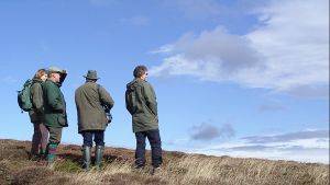
Monitoring Work Underway at Tullychurry Forest
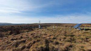
Five different areas of the site are being monitored using shallow groundwater dip wells to assess water table recovery in each area.
These include the three treatment areas (cell bunded area, control area and general drain blocking area), an area of open moorland and an area of standing trees.
Monitoring is conducted every month whereby the fluctuating groundwater level is determined by dip meter. Furthermore, water samples are taken from each of the dip wells and returned to the laboratory where they are analysed for colour (254nm) and true colour (Pt/Co).
In the three peat restoration treatment areas, water level is monitored more intensively by automatic water level recorders. These hourly data are downloaded every three months.
Adjacent to the peat treatments, rainfall is monitored automatically. These hourly data are downloaded every three months.
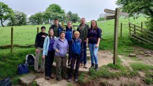
We are keen for monitoring to continue beyond the end of the project to allow for long term learning from this pilot site. The monitoring work, which is carried out by Ulster University, started in early January 2021 and will continue for one year as the project itself will finish at the end of September 2022.