Low Moss bog enhancement 2017
Introduction
The East Ayrshire Coalfield Environment Initiative (CEI) and partners have been working to improve bog habitats in the Coalfields since 2013 as part of the East Ayrshire Coalfields Nature Network and EcoCo LIFE projects. The CEI have delivered 430 hectares of bog enhancement work across three sites since 2013, utilising funding from the SEPA Water Environment Fund, the Heritage Lottery Fund, Cumnock and Doon Valley Minerals Trust, Peatland Action Fund and the LIFE+ financial instrument of the European Community (LIFE13 BIO/UK/000428 EcoCo LIFE). Through the EcoCo LIFE project, the CEI will continue to explore opportunities to work with land managers to enhance bog habitats. The project has commissioned a number of habitat surveys with the aims of prioritising sites for enhancement, gathering baseline habitat data and informing enhancement and management plans.
The CEI have carried out enhancement work at Airds Moss, within the RSPB Reserve; Dalmellington Moss SSSI, a SWT Reserve; Tappethill Moss, a Forestry Commission Scotland plantation; Shiel Farm, at the western end of the Airds Moss SAC; and Low Moss, a raised bog near Lugar. This work has been carried out by highly skilled contractors who have used a range of techniques, including constructing peat and plastic piling dams, creating trench bunds, tree felling and scrub clearance.
The CEI have used their expertise and taken advice from others experienced in bog restoration to use the best available methods to ensure the best possible results. We hope that the improvements at our enhancement sites will benefit bog wildlife, and will be carrying out surveys with volunteers to monitor the success of the enhancement work and to collect biological and habitat data.
Description
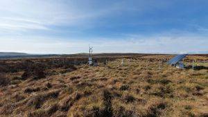
The site comprises predominantly of raised peat bog habitat and it is bordered by improved farmland to the north and west and to the east and south an opencast surface mine. The site is also cut through by a minor road which separates the site in to two sections. The road has a drain cut on both sides and this is removing water to maintain the road integrity. Across the site there is an extensive network of ditches and these have dried the peat surface.
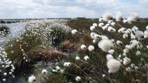
There are areas across the site with moderate peat bog vegetation with NVC community M18a Erica tetralix-Sphagnum papillosum raised and blanket mire, Sphagnum magellanicum-Andromeda polifolia sub-community. This is surrounded on the direr edges by Purple Moor-grass Molinia caerulea mire (NVC community Molinia caerulea-Potentilla erecta, Erica tetralix sub-community). Within the mire community some areas are dominated by Juncus effusus rush on the mineral soil and adjacent to the improved farmland. The habitat within the centre of each section of the site, on both sides of the road, is of moderate quality with a mix of Sphagnum species present with other typical peat bog species including cross-leaved heath Erica tetralix, hare’s-tail cottongrass Eriophorum vaginatum, common cottongrass Eriophorum angustifolium, and bog rosemary Andromeda polifolia.
The site is generally free of scrub since most of the site has historically been grazed. There are small areas of scattered scrub with willow sp. rowan and birch. Heather Calluna vulgaris and Molinia caerulea are dominant across most of the site. Heather is about 30 cm tall and does show some signs of light grazing. The southern and eastern parts of the site are relatively dry with tall heather, dense Molinia caerulea and dense rush species throughout.
There would appear to be a hydrological impact to the peat habitat from the adjacent open cast surface mine. The extensive network of drainage ditches within the site has created an undulating peat surface with a general slope present around the whole perimeter. In these areas water movement is greater and Molinia caerulea and rush species are dominant. There is some evidence of previous peat cutting and the vegetation in this area is dominated by Molinia caerulea and patches of Calluna vulgaris.
Project Aims
The main overall objective is to create conditions on site to allow peat forming vegetation to thrive and begin the process of laying down new peat layers over 90% of the site. This would be achieved within a 25 year timeframe with some noticeable results within the first 10 years.
The second objective is to enhance the site biodiversity by creating conditions for other associated habitats on peat to develop. The main aim for peatland restoration is to restrict, reduce or slow water loss from the peat bog through the ditch network, natural features, sub-surface flow and surface run-off. This to achieve a raise in general water levels to within 10 cm of the peat surface and maintain these levels. This will create conditions for peat forming vegetation to colonise and the conditions for new peat layers to be laid down.
To achieve the objective a series of restoration techniques will be proposed across the site. Proven re-wetting techniques using agreed specifications and methods of installation will be proposed. Each techniques will aim to achieve the main objective with a number of measureable outcome to determine success, these are:
- Re-hydrate the peat surface to achieve general raise in peat water levels to within 10 cm over 90% of the restoration area within five years
- To re-hydrate the acrotelm to create suitable conditions for active peat forming vegetation within 10 years
- To re-hydrate the peat surface to allow for the laying down of new peat layers within 25 years
- To encourage the growth and colonisation of Sphagnum species within the ditch network within five years
- To encourage the growth of Sphagnum species, especially hummock and carpet forming species on the peat surface (beyond the ditches) within 15 years
- Reduction of dominant vegetation creating negative evapotranspiration affects over 90% of the restoration area (e.g. dense heather, grasses sp., dense scrub or trees) within 15 years.
Restoration Delivered
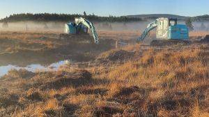
In early 2017 specialist contractors, Openspace (Cumbria) Ltd, used low-ground pressure excavators to install c. 3000 peat dams and 100s of metres of bund to block up drainage ditches and slow water loss across 25 hectares of bog.
Project Name: Low Moss bog enhancement 2017
Organisation / Lead partner: East Ayrshire Coalfield Environment Initiative
Location: Lugar, East Ayrshire
Approximate area covered: 25 ha
Conservation Status: Local Wildlife Site
Predominately: Lowland
Peat Habitats: Lowland raised bog
Project Type: Restoration, Management, Citizen science/ community engagement.
Year Project Began: 2016
Project End Date: 2018


