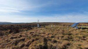
The Yorkshire Peat Partnership (YPP) have been using Unmanned Aerial Vehicles (UAVs) since 2012 to survey and map areas of degraded upland habitats throughout the mountains and hills of the low-rising Pennine mountain range in northern England.
Blanket bogs
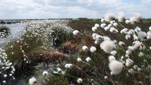
A very special type of ecological habitat known as blanket bog can be found here. These areas of land have been referred to as the United Kingdom’s version of the Amazon rainforest and are home to many unique plants and animals. Carnivorous plants such as Round-leaved Sundew (Drosera rotundifolia) grow in this environment and they are important breeding and nesting grounds for upland birds such as golden plover (Pluvialis apricaria) and dunlin (Calidris alpina).
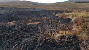
Aerial image of an area of degraded blanket bog captured using a Sensefly eBee with a Canon WX (18.2 MP) camera. © Mark Brown @ Yorkshire Peat Partnership
These areas of land are not covered by trees however but a ‘blanket’ of peat that has formed over thousands of years through the accumulation of partially decayed vegetation such as Sphagnum moss. It can be up to several meters deep in some places.
Due to this they are a massive carbon sink and act as a buffer towards climate change as they sequester carbon from the atmosphere. They are a very important source of much of our drinking water and help to regulate water quality and flood risk.
They are important for our scientific and cultural heritage. Archaeological artefacts are preserved because of the bogs anaerobic conditions and due to this they can provide an excellent record of past climate conditions from the preservation of pollen, insect fragments and testate amoeba.
They are important for upland farming as sites for the grazing of sheep and are also important for leisure and recreational activities.
Despite this most of these habitats are in a heavily degraded state. Mismanagement of this land through burning and overgrazing as well as natural causes such as wild fires are causing much of it to erode away. Once peat is exposed to the elements it rapidly wears away releasing carbon and entering waterways where it turns the water a brown colour similar to that of tea. Peat that is dissolved in waterways causes a problem for water companies as they have to spend millions of pounds each year to remove the dissolved organic carbon through chemical treatments.
Blanket bog restoration
The Yorkshire Peat Partnership aims to reverse degradation of the blanket bog by establishing stable conditions necessary for its recovery.
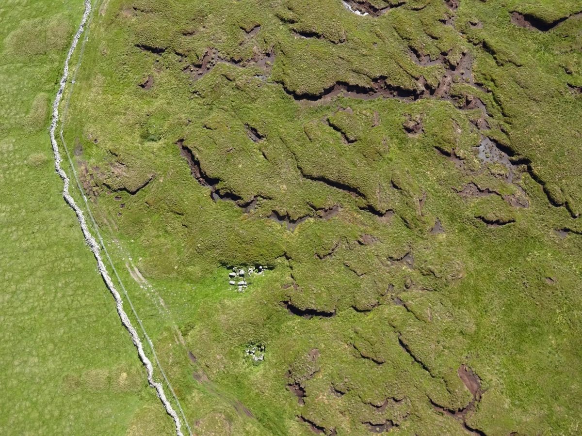
This includes using building dams and barriers to block drainage channels and erosion gullies. This helps to raise the water table and peat sediment is deposited behind the dams instead of being carried off into the waterways.
The sides of gullies that are eroding are often too steep for recolonization by vegetation. In order to aid recovery we re-profile the gully sides to a shallower angle before carrying out bare peat revegetation.
Re-vegetation techniques are used to stabilise the peat and allow colonisation by natural bog species. This includes the application of lime to raise the soil pH, fertiliser to support root establishment and seeding with amenity grass to act as a nurse crop.
A variety of techniques are being trialled to reintroduce Sphagnum mosses to blanket bogs.
LIDAR, DEMs and UAVs
The use of UAVs by the Yorkshire Peat Partnership came about primarily out of a necessity for high resolution elevation data for hydrological modelling purposes within GIS software. We were interested in determining where water was flowing as well as detecting distinct hydrological units within our restoration sites. This information could be used to inform our habitat restoration schemes.
We found that the currently available Digital Elevation Models (DEMs) were of insufficient resolution to detect most of the erosion features that we were interested in. LIDAR of 1m resolution was available but even this wasn’t of a high enough resolution for our interests and coverage at this resolution was limited.
The cost to commission LIDAR surveys using helicopters or fixed wing aircraft was prohibitive. In fact to have a bespoke LIDAR survey carried out for just one of our sites cost approximately the same as one of the first commercial UAVs such that were becoming available at that time.
This made the acquisition of a UAV such as a Sensefly eBee (https://www.sensefly.com/drones/ebee.html) very appealing. Not only would we be able to collect our own imagery to produce DEMs and RGB Ortho-photographs we would also be able to carry out repeat surveys and so it would also prove a useful tool for temporal monitoring of our restoration sites.
Mapping erosion and monitoring the impact of restoration techniques
By carrying out UAV surveys at our restoration sites we are able to collect and generate data at a previous inaccessible scale. Typically we process data to around 3.5cm using photogrammetry software known as Pix4D Mapper. Prior to this we were working with 25cm resolution RGB imagery and 5m resolution DEMs.
The resolution of this data has opened up a whole new realm of possibilities for the geospatial analysis of blanket bogs. We can now identify and quantify areas undergoing or most at risk erosion and use this information to inform us where to concentrate out restoration efforts and therefore target our limited resources.
The Yorkshire Peat Partnership aims to reverse degradation of the blanket bog by providing stable conditions necessary for its recovery
In order to do this we need to identify those areas currently undergoing or most at risk of erosion and this is where the UAV comes in.
We use the data generated from UAV flights to carry out a whole range of analyses. We are a big proponent of open source software and carry out most of our analysis within an open source GIS software known as QGIS (www.qgis.org). This includes but is not limited to surface analysis, hydrological analysis, feature extraction, Object Based Image Analysis (OBIA), 3D visualisation and the creation of cross sectional profiles to determine the dimensions of eroding gullies.
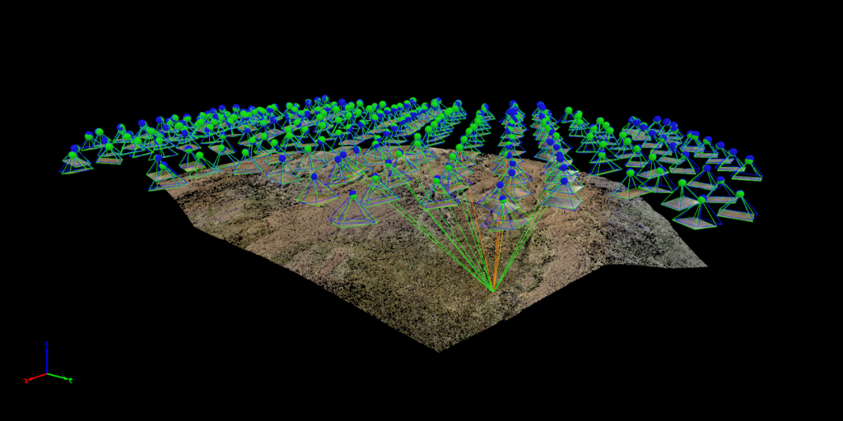
Photogrammetry software (Pix4D Mapper) is used to process imagery captured using the UAV. © Mark Brown @ Yorkshire Peat Partnership
Surface Analysis
There are numerous ways in which a high resolution Digital Elevation Model (DEM) can be used to analyse the terrain of a peat bog. By assuming that exaggerated changes signify likely areas of damage to the bog a standard deviation filter can be run across the dataset to identify those areas with the greatest variation in topography. By applying a threshold to the resulting dataset it is possible to accurately extract those areas that are undergoing significant erosion. We can use this data to quantify the total area of erosion and to map where we require restoration work to be carried out.
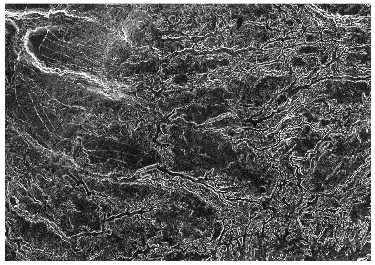
Application of a standard deviation filter algorithm within QGIS to identify areas of erosion. © Mark Brown @ Yorkshire Peat Partnership
Hydrological Analysis
A very important area of our work involves blocking grips and gullies to restore the hydrological integrity of peatland. In areas of dendritic gullying it is very confusing both on the ground and from aerial photographs to assess in which direction water is flowing. By performing hydrological analysis we can identify where water is flowing and therefore map gully systems. Further to this identifying sub-basins within watersheds allows us to target distinct hydrological units.
3D Visualisation
By importing the data into 3D modelling software we can examine our restoration sites from every possible angle without the need to return to the field. We’re literally bringing the blanket bog back into our office.
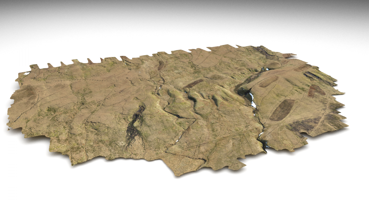
Photorealistic terrain model generated from data captured during UAV surveys visualised within Blender (an open source 3D modelling software package). © Mark Brown @ Yorkshire Peat Partnership
Image classification for the automated mapping of exposed peat and Sphagnum moss growth monitoring
By using image classification techniques with aerial imagery captured by a UAV we can automatically map areas of bare exposed peat. Work that would have previously taken weeks by head-ups up digitizing can now be carried out in a day using the methodologies we have developed. These areas undergo a treatment of liming, heather brashing, seeding and fertilising. These materials are often carried onto site by helicopter in sensitive areas. Due to the cost of these flights it is important give an accurate estimate of the amount of materials that need to be transported onto site in this way.
Cross sectional profiles
It is important for us to know the dimensions of erosion gullies in order for our contractors to calculate the cost to carry out restoration work. Gullies undergo a process of re-profiling whereby the eroding sides are smoothed and levelled to make them suitable for revegetation. We also need to know how wide the gullies are in order to calculate the size of dams to be installed. It is important to know the amount of wood required as once the materials have been transported onto site it is expensive to take them back off.
3D modelling of Peat Reserves
Our field staff collect a lot of important information when out surveying our peat bogs. Equipped with a sub meter accuracy GPS mobile field computer (Spectra Precision Mobile Mapper 120) they record plant species such as sphagnum mosses and take measurements to assess the depth of peat. It is important to measure the depth of peat to make sure we are carrying out restoration on blanket bog. By using geostatistical techniques such as kriging we can predict the depth of peat throughout the blanket bog. By combing the elevation data collected by the UAV with the peat depths collected by our surveyors it has been possible to produce 3D models of sub-surface peat reserves. We can then use this data to calculate the volume of peat beneath our sites and in turn calculate how much carbon is stored there.
Conclusion
Weather conditions prove to be a major constraint in the application of UAVs for surveying peat bog habitats. However when the weather conditions are favourable the resolution of the data that is collected is far in excess of anything that we could purchase through commercial means. Large file sizes put a strain on server capacity and have long processing times for geospatial analysis. However this data allow us to map and analyse peat bogs in ways that we previously couldn’t before and has revolutionised the way in which we carry out the restoration of blanket bogs.
YPP Geospatial Toolbox
The Yorkshire Peat Partnership carry out UAV surveys using a SenseFly eBee. (https://www.sensefly.com/drones/ebee.html). This is a small fixed-wing drone that is proving to be one of the most popular commercially-available drones for surveying and mapping purposes. The UAV is fully automated and flies along pre-defined transects taking photographs along the way.
The imagery that is captured by the Sensefly eBee is processed within photogrammetry software known as Pix4D Mapper (https://pix4d.com/). This software is used to generate point clouds, digital surface and terrain models, orthomosaics, and textured models.
All geospatial processing of the datasets produced from these surveys is carried out within QGIS (http://www.qgis.org). QGIS is an open source Geographic Information System that due to a user friendly interface and a wide variety of processing options is fast becoming the GIS software of choice for ecological and conservation applications.
3D modelling is carried out in Blender (https://www.blender.org/). Blender is an open source 3D modelling software package. It is more commonly used for 3D art, animation, and the creation of computer games.
GIS & Remote Sensing Officer, Mark Brown, from the Yorkshire Peat Partnership recently had the above published in the GeoConnexion magazine. A digital version can be seen here: http://flickread.com/edition/html/index.php?pdf=59970858a8092#65